Andrew and Cecil chose to ride on Sunday. Lynne and I both had weekend commitments but felt that a) we could afford a weekday to ride, and b) waiting another day might improve the weather slightly.
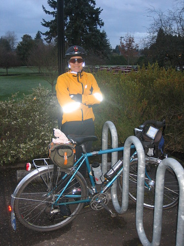 This time of year the starting time of 7 AM means that you will want blinkies and reflective gear for at least the first part of the ride. Although we had plenty of sun before we made it to Gales Creek, notice how the flash on my camera went off and really trashed Lynne's pre-ride photo here.
The ride starts out of McMenamins Grand Lodge and heads west then north out of Forest Grove. Motorists in this part of the world are pretty polite, though you need to be concerned due to the early hour of the morning. Did you know experts say that you really aren't awake for as much as an hour after you get up?
One thing that doesn't change is the terrain. I
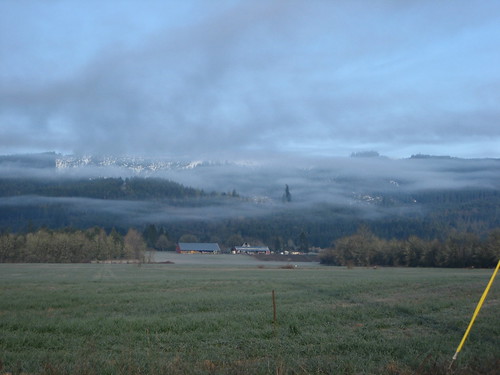 t seems like the entire route from the edge of Forest Grove to SR-6 is a slight uphill. In spite of that, the emerging sun gives you some tremendous vistas of rural western Oregon. Don't forget to look to take a look! I've lived in Oregon almost 30 years, and I still don't get tired of the beautiful interplay of clouds, hills, and sun. Here you see rain clouds and snow capped hills to the west
Snow capped. Uh, yeah, right. More on that in moment.
When you make it out to SR-6 (the "Wilson River Highway"), you have the short leg up past Glenwood to the Timber Road junction. When we road this section, not only did we have rumble strips on the shoulder, but the shoulder itself is extremely dirty. Be careful, especially if you need to hop into the murder vehicle lane to avoid trash (those rumble strips are pretty rough when you're on a bicycle).
The turnoff onto Timber Road was approximately 0.5 miles earlier than indicated on the cue sheet, and this discrepancy stayed pretty constant for me for the remainder of the ride. Or, as they say, "your mileage may vary".
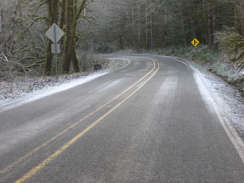 As you start to rise on Timber Road, you may discover that the road surface is heavily sanded and graveled. On our return in the afternoon, we saw that Washington County and come through and (sort of) swept the roadway. However, I wouldn't be surprised if there's more crud on the road by the time Saturday rolls around.
Uhh..Oh yes...about that snow. Folks in the upper reaches of the Tualatin Mountains have noted snow just about every morning every last week, and as the store clerk at the Birkenfeld Grocery put, "it could stop any time now."
As we climbed, we saw a light dusting, but the road surface was quite manageable. However, if we continue to subfreezing overnight temperatures, be extremely cautious of black ice on this stretch; it is heavily shaded and protected from winds, so the potential exists for very treacherous traction here.
After about a mile of clear cuts (legacy of Ronald Reagan and George Bush the First), you (essentially) summit. I essentially because there's actually a slight bit of climbing on the far side of Timber before you drop down to US-26.
A political aside: Reagan and Bush so thoroughly raped the Pacific Northwest that we actually have less old growth forest left than places in the east such as the Catskills, Adirondacks, or the Blue Ridge. All you have to do is to use an airplane or get away from the freeways and US highways and you'll see what my grandchildren will get to enjoy until they're my age.
 Ah well. Back to the ride. Be careful on your downwards descent into Timber. On top of sketchy ice conditions and the potential for sand and gravel, you have a steep downhill right before the train crossing, and the train crossing is really bad. Lynne walked her bike over it; I just picked my path carefully (1970's technology 27 by 1.25" tires have their uses).
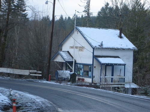 Don't blink as you pass through Timber. It's small, but it really does have a bit of charm. You have two sharp hairpins past the railroad tracks, a slight climb, and then you get to start your downhill paycheck.
After about a mile and a half, the clear cuts stop (because you're getting close to US-26 and we wouldn't want the tree huggers in Portland to know what's going on, would we?). Another mile and a half and you cross straight over on Timber Road and continue north/northeast towards Vernonia.
It's along here that you start paralleling the course of the Nehalem River. Recall there was a flood that was on the national news last fall. The formaldehyde trailers are in place now, but if you look closely you can still see the occasional screen door or other household debris above your head in the trees next to the river.
 It was about here that I was grateful that we hadn't ridden on Saturday or Sunday. The weather was definitely better than either of the previous days, but we still ended up with the weirdest precipitation. Seriously, it snowed on us once and hailed on us twice, but not once the entire day did we actually get wet.
The road surface was marginally better here than south of US-26, but pay close attention around mile 32. There is a "rough road" sign, and this means you. You have about 30 feet where the road has been just plain totaled. It looks a lot like some drainage problems that will need the summer in order to correct.
As we turned north onto SR-47, Lynne and I had the bright idea that we'd try the Banks-Vernonia Trail, which has ready access along there. We took the first access road, went a tenth of mile, and then came across a "bridge closed" sign. Whoops, no. Back to the murder vehicle lane. Lynne tried again a quarter mile later and we immediately found an entire section of the pavement that had gratuitously slid about 15 feet to the right off of its bed.
Bottom line: don't bother, just stay on SR-47.
A note about SR-47. At this point I've ridden most sections of Columbia, Washington, and Yamhill counties, a large part of Marion and eastern Multnomah counties, and even chunks of Polk, Tillamook, Lane, and Clark County Washington. However, SR-47 is the one of the few places I've ridden where murderists have thrown trash at me, screamed epithets at me, and tried to run me off the road. And that trash throwing incident? That was in Vernonia. Be careful. If that wasn't enough, there were an astounding number of log trucks on the road as we did this ride on a Monday. I think it's a bit lighter on weekends, and log truck drivers as a lot are pretty careful, but at least one log truck murderist underestimated the length of his truck and cut back over into our lane a bit too early.We didn't have the tremendous problems that Cecil and Andrew did getting into Alexander Park in Vernonia. The road surface at the cutoff is indeed a bit rough, but certainly no worse than what you saw at mile 32 earlier.
As you head down Bridge Street you will see ample evidence of the flood. It's also starkly apparent which property owners had flood insurance (very new looking) and which ones didn't (flood damage, right along the main thoroughfares). Turn on State Street and start a bit of gratuitous climbing, and be sure to answer your control question at Burn Road and turn back.
Make a left on Stony Point Road and start some more climbing. It's actually rather pretty here, in an almost rural kind of way. However, this is where we started seeing the dogs. Lots of dogs. Who have more enthusiasm than common sense. Lynne might characterize them differently, but I didn't see any that were a serious threat, except for the basic lack of any sense of self preservation that a dog gets when it's chasing. One of these could collide with you just out of canine stupidity as you go by, so I recommend either speeding up so that don't get that opportunity, or slowing down to the point that they cotton to the fact that instead of prey, you are in fact a human. Like I said, all the dogs I saw were of the tail-wagging "let's chase the fast moving prey thing" variety, not genuine threats (which do exist, unfortunately). You know: growling, tail down, follows you past their property line, looking for a place to latch the teeth onto. I really didn't see any of those on this ride.
 At the tee turn left (north) on SR-47 and follow the Nehalem all the way out to Birkenfeld.
It looks like the single-lane road sections with traffic lights (where they were rebuilding the bridges) are finished. If you're an urban commuter like me, you'll still find yourself automatically changing lane position to hit the defunct sensor loops as you go by.
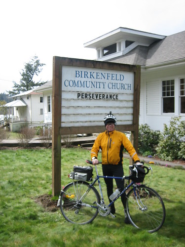
You'll know when you're close to the turnaround because of the church. The sign made this randonneur "gimme" picture (sorry).
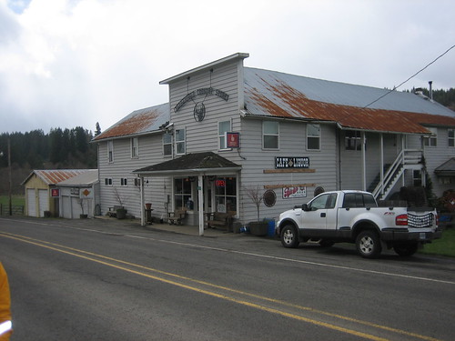
The Birkenfeld General Store is definitely the hotbed of activity in this part of the world. Need a big game tag? Need to load up on bourbon or vodka? Want to know when the next A.B.A.T.E. poker run is? Want a grilled cheese sandwich or an espresso? It's all here. Everyone who came into the store seemed to know each other by name, and I think I saw one person come in and leave with a loaf of bread without money change hands (credit at a grocery store? Shades of the 1950's...) You can even buy a T-shirt or a sweatshirt with the company's name and logo. It certainly has a following.
The return is pretty much a straight shot back to Forest Grove. Of course, you're following the Nehalem upstream now, so be prepared to work a bit trying to get back to Vernonia. When you pass Stony Point Road (and continue straight), beware of more happy dogs on the right. The stretch of Timber Road leading to US-26 is stultifying. I guess the snow and hail kept me distracted the first time.
Heading back up to Timber, don't despair. You're at a higher elevation than when you were climbing up from SR-6, so the three miles really isn't that bad.
After you summit past the railroad tracks, do not take a carefree paycheck back down to the Wilson River Highway. Although you probably won't encounter black ice this late in the day, I saw more than a few stretches of road that were only clear in the double tracks left by the passing murderists. Also, you have sharp turns through exactly those same places that have been heavily sanded, so you run a real risk of losing traction or risking your life in the oncoming lane if you hit them too fast. Just don't overrun your sight clearance, pick your entry speed, and--instead of picking an apex--expect to hold your line and to find one or two pieces of gravel in whatever tire track you're in as you enter the corner. (If you don't understand that, it's motorcycle talk. Lynne calls me "Whacko Boy Junior" because the only rider she normally rides with me who's faster on the downhills, Don "Whacko Boy" Bolton, is also an ex motorcyclist).
It's downhill to the Glenwood open control, but don't forget to stop and get your brevet card signed (or a receipt). From there, you'll feel like George Hincapie as you fly down Gales Creek Road and then back to Grand Lodge. Be sure to bring along your swimsuit; for a $5 charge (waived if you have dinner) you can soak in their Japanese style soaking pool. And, you will have dinner with us, won't you?
See you there!
The few photos I didn't work into this ride report are here.
Also, check out Lynne's photos.
Music: If Only She Woulda (Frank Zappa, You Are What You Is)


No comments:
Post a Comment